Winter Storm Fern Set to Impact North Texas Friday Through Monday
Share News:
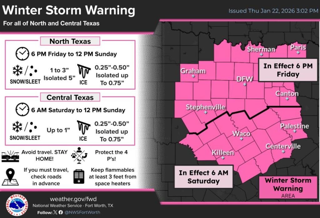
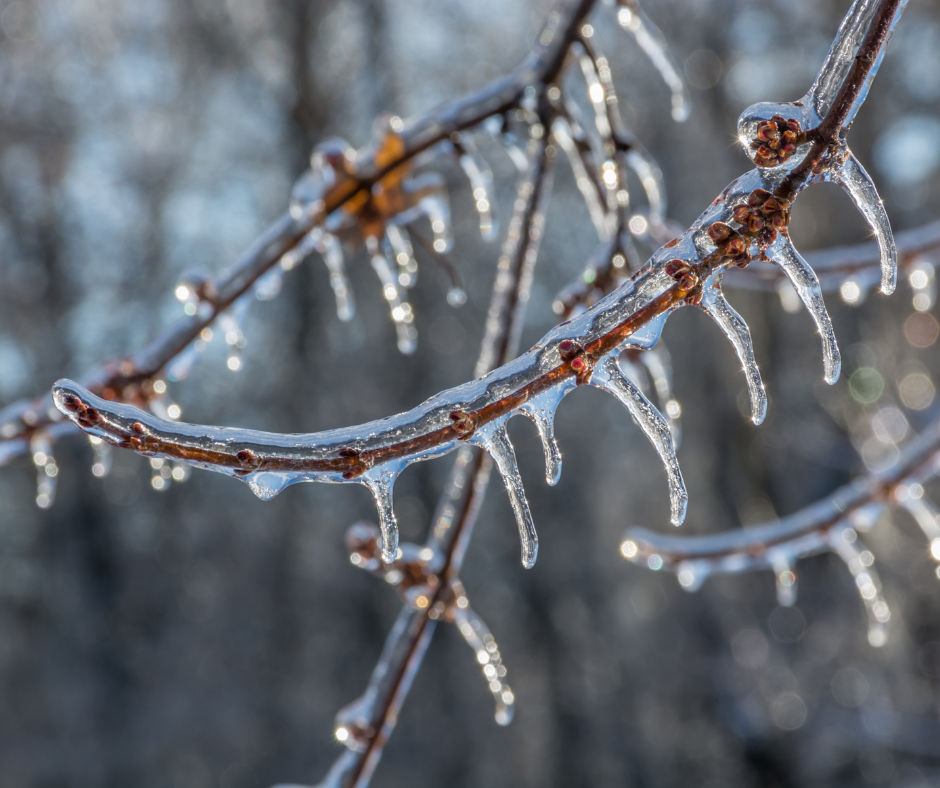
Winter storm Fern, a potent arctic cold front, is set to sweep through North Texas, bringing a messy mix of freezing rain, sleet, ice, and snow. Sub-freezing temperatures are expected to linger through Monday, Jan. 26, prompting the National Weather Service to issue a Winter Storm Warning Thursday afternoon for the Dallas–Fort Worth area as travel and infrastructure concerns ramp up heading into the weekend.
1/22 4 p.m.: Updated weather models show the arctic cold front is slowing down.
Early forecast models showed this storm arriving Friday morning, but updated forecasts show the arctic blast has slowed down, moving the time of impact later mid-day Friday, Jan. 23. Precipitation will transition from rain to freezing rain and sleet as temperatures drop below freezing Friday into Saturday. North Texas is likely to see sustained cold through Sunday afternoon, with overnight lows dipping into the single digits to mid-teens.
You know what that means? Pete Delkus is donning the ice-man suit, and North Texas is collectively bracing for impact. But before you storm the grocery store like a contestant on Supermarket Sweep, here are a few things we’re keeping our eye on as weather forecasts, infrastructure updates, and closures come in.
ERCOT Grid & Electricity Outlook
At this writing, no grid emergency has been declared, but conditions bear monitoring as demand climbs and temperatures plunge. Severe multi-day freezes have in the past strained the grid, leading to rolling outages and conservation appeals during extreme events. Residents should keep an eye on updates from ERCOT and local utilities in the days ahead.
What to watch for:
- Grid conservation alerts — If ERCOT issues a conservation request or emergency alert, plan to reduce non-essential electrical use during peak evening hours.
- Local outages — Ice accumulation on infrastructure and high electricity demand can elevate the risk of localized power outages.
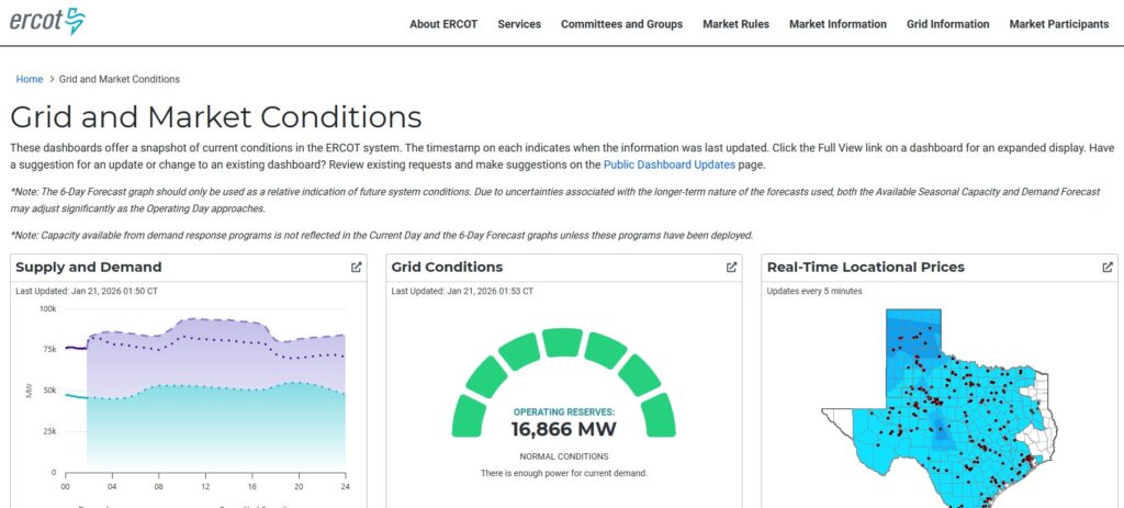
ERCOT publishes a detailed dashboard showing real-time electricity conditions on Texas’ energy grid. There’s a lot of data here, but since the catastrophic winter storm of 2021, ERCOT has made a point of increasing transparency by giving the public access to these system metrics.
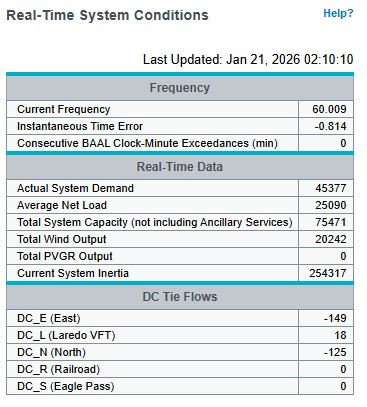
If you’re looking for a simpler, mobile-friendly option, ERCOT also offers a real-time system conditions chart that shows how much energy is being used and how much energy the grid can produce. The numbers to look at are in the second set of boxes: “Actual System Demand” and “Total System Capacity.” Right now, the margins of system demand and system capacity are healthy. By comparison, on the night before the grid failed in February 2021, that margin shrank to just over 1,000 megawatts — a precarious situation documented in the archive report below.
Locally, you can check the Oncor Stormcenter Dashboard for neighborhood-level outage information. This is particularly useful in areas with above-ground power lines that are more vulnerable to ice accumulation and falling tree limbs.
Helpful links:
Protecting Your Home: Pipes & Utilities

Multi-day freezes pose a serious risk for frozen and burst water pipes — one of the most common and costly winter freeze damages in North Texas, the Texas Department of Insurance says. Steps homeowners can take now include:
Insulate exposed pipes in attics, crawl spaces, garages, and along outside walls with foam pipe insulation or heat tape.
Cover outdoor faucets and disconnect garden hoses.
Open cabinets under sinks to let warm indoor air circulate around plumbing.
Let faucets drip slightly during the coldest overnight hours to keep water moving and reduce freeze risk.
Know where your main shut-off valve is and how to use it in case a pipe bursts.
Review your insurance coverage for frozen-pipe damage and document your preparation steps — many policies require reasonable preventative action for coverage eligibility.
Landscaping & Plants: What to Do
Freezing temperatures and ice can do significant damage to gardens, lawns, and vulnerable landscape plants. Texas A&M AgriLife Extension recommends the following steps to protect plants ahead of a hard freeze:
Water soil thoroughly before the freeze — moist soil holds heat better than dry soil.
Cover tender plants with frost cloths, old sheets or burlap — avoid plastic directly on foliage.
Apply mulch (2–3 inches) around the base of shrubs and perennials to insulate roots.
Move potted plants indoors or to sheltered spots; if leaving outside, cluster together and wrap the pots.
Remove covers once temps rise to avoid heat stress.
Hard freezes can leave lasting damage. Post-freeze, wait until spring to assess and prune only dead wood to avoid unnecessary stress on plants.
People, Pets & Travel Safety
Stay off roads once freezing rain begins — bridges and overpasses ice first.
Bring pets indoors and make sure outdoor animals have insulated, dry shelter and unfrozen water.
Stock essentials before the storm — groceries, meds, and warm clothing — but avoid panic buying.
Announced Closures & Cancellations
Already announced:
Texas Rangers FanFest scheduled for Saturday, Jan. 24 at Globe Life Field has been cancelled due to expected winter weather and safety concerns.
We’ll add school closures, though after-school activities have been cancelled in some school districts, as well as transit advisories, city service changes, business cancellations, etc., as they’re announced.
And for Some Comic Relief
Before things really get weird — and they always do — here are a few CandysDirt winter-storm classics to keep handy: