PD-15 Traffic Study Shows Little Impact From Proposed Development
Share News:

If traffic is the major argument against redevelopment in PD-15, a new study could render it moot.
The traffic study, conducted by Pacheco Koch and funded by the Preston Place condos, was posted online Tuesday and makes for interesting reading. The map above shows the study area bounded by Preston Road, Northwest Highway, Walnut Hill, and Hillcrest Road. It goes well beyond just PD-15 which should be good news for the surrounding Pink Wall and Preston Hollow neighborhoods.
The report itself is 120 pages long with two 15-page sub-reports on the potential of adding traffic signals to either Edgemere Road or Tulane Boulevard at Northwest Highway. Skimpy it ain’t (so I’ll excuse you to read the first 19 pages).
What makes this report different from other traffic studies I’ve read is that it includes extensive thought and recommendations on how things currently work and could work in the future. While I’m open to nearly all its findings, I have an issue with their thoughts on opening Tulane Boulevard. But I get ahead of myself, let’s start with the traffic numbers before we visit how to shuffle it around.
Looking back to the comments from an April 24 column I wrote, a reader asked what I thought the traffic impact would be. I answered my best armchair estimation saying we needed to wait until the professionals delivered their goods.
How’d I do?
First of all, my numbers assumed a “trip” was round-trip while the study classes “trip ends” as being either an “in” or “out” (essentially a half-trip). Also, the study assumed redevelopment of all four low-rises while I only included the three known quantities of Preston Place, Royal Orleans and Diplomat (as far as I know Diamond Head condos isn’t under nor seeking a contract at this time). So while I claimed at 90 units per acre there would be roughly 360 new units based on roughly four acres, Pacheco Koch adds 180 units to that to account for Diamond Head’s two acres.
The study’s resulting estimate is that each new dwelling unit will contribute 4.4 one-way trips each day or a pinch over two round trips. My calculations estimated 2.2 roundtrips or 4.4 one-way trips per unit. SPOOKY!
I had also written that depending on the number of one-bedroom units and units with one occupant, this number may go down – which I believe, given the high percentage of existing single occupant units, is still true.
The study also evaluated what would happen if the developers took all the sweeteners in the draft PD document that would see density move from 90 units per acre to 125 per acre.

Typo above states that in Scenario A there will be 4,951 trips when it should be 4,363
At 90 units per acre, total traffic would increase by 72 percent from existing levels. This translates into an increase from today’s 2,024 one-way trips per day from Athena and Preston Tower to 4,363 total one-way trips at full build-out. You may be asking, “how can it be 72 percent when 4,363 is more than double 2,024 trips?” Easy, today the low-rises account for 519 one-way trips that become part of the 4,363 trips of tomorrow. At 125 units per acre, the traffic increases 104 percent above existing levels to 5,191 one-way trips per day.
Again using 90 units per acre the report notes during peak morning rush hour there will be a combined total of 306 in/out trips compared to today’s 177 one way ins/outs. That’s 128 additional cars per hour in the morning or basically two cars extra per minute added to today’s 2.73 cars per minute (roughly five cars per minute). In the evening rush, peak hour ins/outs will be 357 total compared to today’s 210. That’s 2.45 additional ins/outs per minute added to the existing 3.5 one-way trips (6 cars per minute during evening peak-hour).
Of course, all those cars aren’t going to the same place. The report estimates that 50 percent will be coming/going from the west, 40 percent will be coming/going from the east, and 10 percent will come from the north via Edgemere Road. This should ease traffic concerns for the single-family owners to the north.
These may sound like big numbers, but they’re really not. One-third of all traffic occurs during the two hours of morning and evening rush and that only adds three cars per minute on average. Those cars are further split between in/out and north, east and west traversal. And that’s the worst. For those not part of the rush-hour traipse, the result is less than a blip.
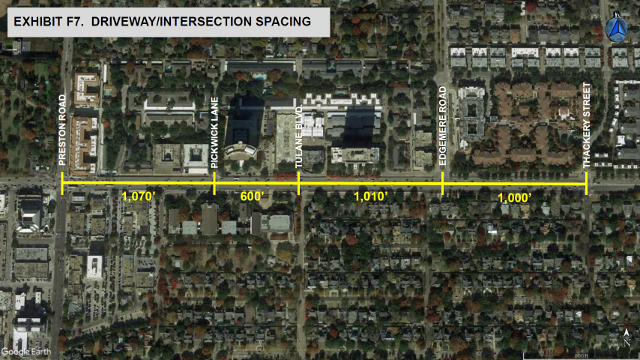
Measured another way, the City of Dallas Thoroughfare Plan lists 10,000 vehicles per day as the operational capacity of a two-lane road (the interior roads within the Pink Wall). They also say that any road operating at less than 65 percent capacity is offering a good level of service. The current daily volumes on Pickwick Lane (1,671), Bandera Avenue (1,184) and Edgemere Road (2,274) are at worst 23 percent of capacity. Even where all the additional traffic shunted to just one of those roads, it wouldn’t reach 47 percent capacity with 90 units per acre built, and only 54 percent at 125 units per acre – and all the traffic isn’t going to go to one road.
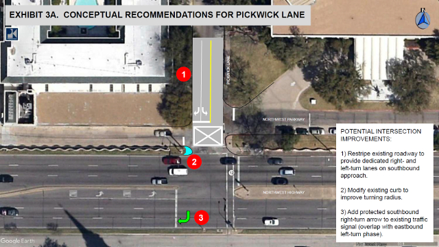
Traffic Signals: Pickwick Lane
The report concluded that if there’s a wait at Pickwick, it’s not Pickwick’s fault, but the longer-than-average green light for Northwest Highway traffic resulting in a shorter Pickwick green (endemic of all little roads intersecting with large roads). It also says that while Pickwick “knows” when a car is waiting, its dependent on where the car is waiting. The frontage road doesn’t “report” people waiting, thus it doesn’t shorten the red light.
To help Pickwick maximize flow, the report recommends that parking along Pickwick near the light be eliminated and a dedicated right turn lane be put in. Coupled with this would be the long-awaited protected right turn arrow (for when there’s a left turn arrow from eastbound Northwest Highway onto Pickwick). Before any Imperial House or Preston Tower residents complain about the loss of parking along Pickwick, know that the original PD-15 documents state, “Parking is prohibited on both sides of Pickwick Lane from Northwest Highway to Bandera Avenue.” So you shouldn’t have been there anyway.

Edgemere Road
Edgemere gets sexy. I’d long wondered about the enormous 45-foot wide median stretching from Northwest Highway almost to Northwood Road. I’d hoped the city would use the land to install an underground water vault to keep the neighborhood dry (first thought was locating it under Preston Place). No water vault, but the center green median (only used by incontinent dog owners) gets a makeover. The road becomes a little more twisty to slow traffic and shuffle the green space to both sides of the road. I like it a lot (like it better with a water vault under it).
This is a lead-up to the traffic study’s recommendation of a traffic signal at Edgemere Road and Northwest Highway. I’ll admit I’m not a fan of this plan for two reasons. First, the only straight-shot to the intersection from the proposed development is the frontage road. Second, making a left or right from the frontage road is a safety hazard resulting in a U-turn on one direction. I purposely avoid Edgemere and go to Thackery so turns are at right-angles. A light at Edgemere will send safety-minded drivers zig-zagging down Diamond Head Circle, left to Baltimore, right to Bandera and finally right to Edgemere.
But A+ on the greenway.
Tulane Boulevard
I’ve been a proponent of opening Tulane to Northwest Highway and shunting all the new traffic directly out onto Northwest Highway. TxDOT doesn’t like that because at 600 feet from Pickwick they feel it’s too close to have another traffic signal. My counter is that if the lights are synchronized, it doesn’t matter.
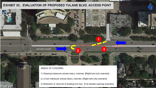
The other issue is First Baptist Church’s elongated left-turn lane on Northwest Highway. Opening Tulane would interfere with it (Sunday mornings). The answer to this is really simple.

Highway turn lanes routinely cross intersections, why not at Tulane?
Either cut the church’s turn lane by a car length or two to allow for the intersection OR extend the turn lane through the intersection (the same way turn lanes extend across intersections on every highway in Dallas). A signal at Tulane eliminates the zig-zagging through the neighborhood that a signal at Edgemere creates. Figuring out an intersection at Tulane is worth the energy especially when the church turn lane’s current function is to serve a few hours of Sunday morning traffic.

Stopping cutover traffic from U-turning onto Northwest Highway
There is some hope though. While a signal might not be possible (keep fighting), it’s possible that Tulane can be opened to allow exiting westbound traffic to turn right onto Northwest Highway as well as eastbound traffic to turn right and enter Tulane.
The concern is for folks exiting Tulane, cutting across Northwest Highway and sailing into the church’s left-turn lane to make a U-turn onto eastbound Northwest Highway. (The same sort of thing many try to do when exiting Preston Center Plaza to make the quick left onto Pickwick.) A simple flexible blockade (above) would prevent the cutovers into the church’s turn lane.
All in all, the estimated traffic resulting from complete redevelopment was a match for my thoughts – pretty minimal. The suggested mitigations at Pickwick Lane, Tulane Boulevard and Edgemere Road should be explored by the city and the neighborhood.
At the April 18th CPC meeting on PD-15, opposition lead speaker Carla Young questioned the validity of traffic studies. She also said they’d still oppose the city’s draft PD even if the traffic study found the impacts of development to be light (because they disagree with the whole PD-15 rewrite process and results).
Like so many things these days, solid research and numbers will hold no sway with those pre-programmed to disbelieve whatever they don’t like. Expect plenty of study poo-pooing by the opposition at the June 6th CPC meeting.
Want to read the report? Click here.

Remember: High-rises, HOAs and renovation are my beat. But I also appreciate modern and historical architecture balanced against the YIMBY movement. In 2016, 2017 and 2018, the National Association of Real Estate Editors recognized my writing with three Bronze (2016, 2017, 2018) and two Silver (2016, 2017) awards. Have a story to tell or a marriage proposal to make? Shoot me an email [email protected]. Be sure to look for me on Facebook and Twitter. You won’t find me, but you’re welcome to look.


Laura Miller’s big lie was all about the terrible traffic redevelopment would bring. Once again, she lied to suit her own purposes and to rile everyone up just to get elected.
I’ve been waiting for your article to explain what this means. Thanks for the work. However, early on you state this: “The map above shows the study area bounded by Preston Road, Northwest Highway, Walnut Hill, and Hillcrest Road. It goes well beyond just PD-15 which should be good news for the surrounding Pink Wall and Preston Hollow neighborhoods.” I don’t believe that is correct. Yes the map shows the area at large, showing stop signs and traffic signals all the way to Walnut Hill, but as far as I can tell the study does not cover that area at all.
From paragraph 5 of Consultan’s Comments Response Letter, it appears that there was no study north of Bandera: “Study should identify current conditions, operations and traffic impact to residential streets located north of PD 15.”
Response by Pacheco Koch: “The study area discussed with the City of Dallas staff at the start of the study was limited to the local streets within PD 15. The results of those analyses indicate that those
intersections operate very efficiently (i.e., good Levels of Service) under current conditions.
Even with the addition of projected traffic from the potential redevelopment within PD 15, the
intersections are anticipated to continue to operate at very good conditions.
However, based upon multiple field visits to the study area during peak hour periods, I believe that the intersections north of PD 15 operate at similar (i.e., good Level of Service) conditions and will continue to do so after the potential redevelopment within PD 15. ”
I am not a traffic study expert, but I don’t see a thing abut the impact north of Bandera other than an estimate that 10% of the trips from PD-15 will send people to/from Edgemere, and the comment above that things seemed okay when the consultant was studying the areas within PD-15, the latter of which I hope we can agree is not scientific. Is there any hard data for north of Bandera in the report? I could be missing it.
Yes, your last paragraph is right. What Pacheco Koch tracked was traffic arriving/leaving the area – including traffic going north on Edgemere. That traffic was ~10%, which given the already low numbers for total traffic movement shows that traffic on residential streets north of PD-15 (generated by PD-15) is almost nothing.
.
So those northern streets should look for other reasons if they feel their traffic is a problem.