Dallas City Council Can’t Agree On Redistricting Modifications, Sets Another Meeting Next Week
Share News:

Just one week away from the U.S. Justice Department deadline, the Dallas City Council on Wednesday could only agree on one thing: to hold yet another special meeting to discuss the boundaries of the city’s 14 districts. The panel will reconvene Monday at 3:30 p.m.
The council spent hours Wednesday haggling over a few modifications to the Redistricting Commission’s approved map, which various council members proposed in a 23-page memo. If the council can’t agree by the June 29 deadline, the redistricting map approved by the Commission becomes the city’s default submission.
The new district boundaries will become effective in the May 2023 council election and remain in effect for 10 years, when adjustments are again made to account for changes in population as recorded by U.S. Census data. (Click to see enlarged district map.)
Resident Feedback
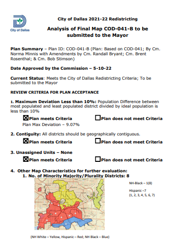
The Redistricting Commission approved in a 10-5 vote on May 10 a map that was met with resistance by residents, who claimed it was racially divisive, politically motivated, or didn’t meet the intended purpose of evenly distributing population while keeping neighborhoods intact.
A resident, who said he was the only Black speaker to submit maps to the redistricting commission, expressed interest in retaining “four winnable Black council seats” — in Districts 3, 4, 7, and 8 in South Dallas. Some of the proposed amendments would “dilute the Black vote,” he said.
“Please approve map 041-B, which was presented to you by the Redistricting Commission,” he said.
Several other residents, however, supported the council-initiated amendments to map 041-B, particularly emphasizing a desire to keep the Parkdale neighborhood in District 7, as proposed by Councilman Adam Bazaldua.
“As this redistricting process is wrapping up, I wanted to take this opportunity to thank you all … for your attention, your sense of balance, collaboration, and care through this process, and it’s taken a while,” said Lakeshore Drive resident Melanie Vanlandingham, a landscape architect who volunteered her services in drawing some of the proposed maps. “I especially want to thank all the citizens … They all came together to help create this new redistricting map to make sure of its fair representation for the next 10 years. I’ve been really proud to be part of this.”
Modifications
The Redistricting Commission’s Map 041-B was created by District 14 Redistricting Commissioner Norma Minnis and later amended by Minnis and community leaders Randal Bryant, Brent Rosenthal, and Bob Stimson.
Council members agreed on June 8 to a proposal by District 5 representative Jaime Resendez to extend the southeastern border of District 5 to include River Ranch and The Texas Horse Park. The approval didn’t stick, though, because the council simply approved the modification and failed to get the required 12 votes on a comprehensive map.
Additional modifications to the Redistricting Commission Map 041-B were approved by city council on Wednesday, but are also no good until the panel can agree on a comprehensive map.
District 4 Councilwoman Carolyn King Arnold’s modification that would “put Kiest Park and the community back together [in District 4] to enhance unity” was the first to pass. The measure also moves Hampton to Illinois to Rugged to Kiest Boulevard from District 3 to District 4; and moves boundaries of R.L. Thorton Freeway to Ledbetter Drive to Marsalis Avenue to Laureland Road from District 4 to District 3.


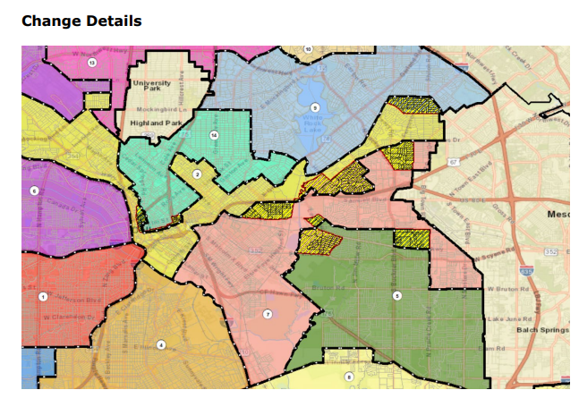
District 2 Councilman Jesse Moreno and District 7 Councilman Adam Bazaldua’s modification, which would keep Owenwood in District 2 and Casa View in District 9, failed due to a lack of support. It needed 12 votes to pass and garnered 11.
The full description of the modification is to amend district lines for districts 2, 5,
7, 9, and 14. The modification “maintains communities who share similar interests such as Owenwood, Parkdale, Ash Creek Greenbelt, Claremont, Hillridge, Old Buckner Terrace, and Lakeland Hills. The redesigned borders will allow for the continuation of collaboration between neighborhoods and community stakeholders for ongoing and future capital improvement projects, corridor studies, and future development of parks and recreation centers in the area. Collaboration and funding for capital improvement projects are in place for the Parkdale and Ferguson corridor study and Lawnview public improvements. The proposed map is designed to keep the neighborhood of Parkdale/Lawnview intact with Parkdale Lake and keep the community in District 7. Over the past few decades, the neighborhood has been advocating and working hard to keep their community together. The map is also designed to keep Deep Ellum Bark Park, Harwood Park, and Lubben Park together. Adjusting the lines, will prevent disruption of the progress being done and will maintain communities together. The changes in District 9 wereadjusted to keep the Casa View neighborhood together.”
“Let’s do what’s right by the people and the city of Dallas,” Moreno said.
Councilman Jaime Resendez said he could not support the change because it would reduce his District 5 by 5,000 residents, which would create the lowest population and lowest voter turnout of the city’s 14 districts. District 1 Councilman Chad West also expressed opposition, saying he wouldn’t support a modification unless it had unanimous council support.
Resendez presented his own modification, which extends the northwestern boundary of District 5 to include Parkdale Lake. The change had no impact on population or demographics and failed because it did not receive the required 12 votes.
A modification proposed by District 13 Councilwoman Gay Donnell Willis and District 6 Councilman Omar Narvaez was approved. The measure uses Lenel Place as the border between D6 and D13 in Midway Hollow (south of Walnut Hill/ east of Marsh Lane/ north of Northwest Highway/west of Midway Road); moves into D6 the neighborhood between Northaven Road and Royal Lane, west of Webb Chapel; and keeps neighborhoods south of Forest Lane between Josey Lane and Webb Chapel (north of Royal) in D13.
Council members said Wednesday it’s a worthwhile endeavor to continue negotiating and fighting for the communities they represent.