You probably need some solitude and a break from family and festivities right now. Go grab a hot toddy and head to a quiet space with your computer — I’ll wait!
Ready? Today I’m giving you more insight into finding details about your historic house with Sanborn Maps.
Hopefully, you read my post last week, delved into the Dallas Public Library’s archives, and found some interesting tidbits about your house. Now you’re jonesing to know more, right? Once you go down the research rabbit hole, it’s hard to stop.
What is a Sanborn map, and why is it important?
The Sanborn Map Collection is the most accurate and detailed building record in existence. In 1867 The Sanborn Map Company began mapping twelve thousand cities and towns across the United States, Canada, and Mexico to assess their fire risk. Each map offers block-by-block details of residential, commercial, and industrial buildings that include the street address, size, shape, construction materials, and the number of stories.
The other cool thing about these maps is they were regularly updated until 1950 when the last catalog was published. If an owner added a porch or a second floor at some point, the exact date and what materials were used are available on a Sanborn map!
Briggs Freeman Sotheby’s International Realty agent Elizabeth Mast uses them regularly when advising clients who are purchasing historic homes.
“Sanborn maps define the exact location of your house and auxiliary buildings like garages or back houses,” she said. “This information is essential in getting a Certificate of Appropriateness for work you may want to do on your home.”
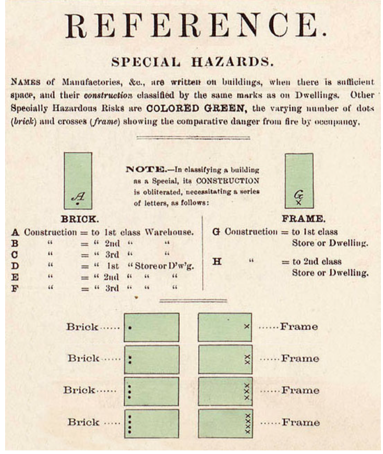
There is a key on the first page of every Sanborn volume so you can figure out what the colors and abbreviations mean. The Library of Congress explains it best:
Sanborn Keys & Colors
Fire insurance maps are distinctive because of the sophisticated set of symbols that allows complex information to be conveyed clearly. In working with insurance maps, it is important to remember that they were made for a very specific use and that although they are now valuable for a variety of purposes, the insurance industry dictated the selection of information to be mapped and the way that information was portrayed. Knowledge of the keys and colors is essential to proper interpretation of the information found in fire insurance maps.
Color
Color plays an important role in Sanborn map reading. In Example 1, we see that brick and tile are represented with a reddish/pink color. Several advantages demonstrate themselves when using color: a) the mapmaker can easily and quickly convey information; b) space formerly used to convey this information can now be used to convey more detailed information; and c) uniformity across all the maps is achieved and maintained.
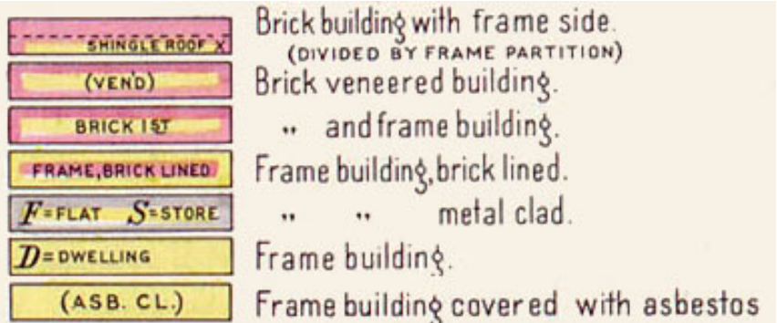
The use of yellow indicates frame, or wood, structures. Example 2 shows the use of framing on the inside as well as outside of buildings. Along with the color indicators, the map uses basic abbreviations to convey other information. S = store, D = dwelling, and ASB. CL. = asbestos clapboards.
Library of Congress
You can see how this would benefit any owner of a historic property who is concerned with restoration. I have a bay window on my 1927 home that I know is not original. One of my holiday missions is to find out what kind of window was originally in place. Sanborn maps are the best resource to find out that detail.