Dallas City Council Approves Final Redistricting Map With Modifications, But Not Everyone is Happy With it
Share News:
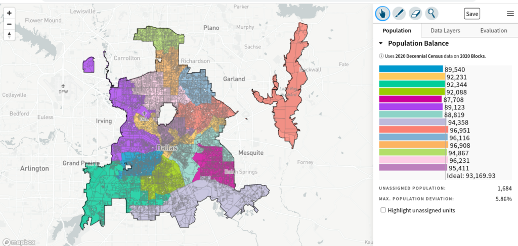
With the clock ticking on the U.S. Justice Department’s June 29 deadline, the Dallas City Council approved Monday a redistricting map that incorporated citizen feedback and specific requests to keep some neighborhoods intact.
Not everyone was pleased, however, as one suggested modification was not approved and council members were not permitted to discuss the pending modifications during Monday afternoon’s meeting, prompting one unidentified elected official with a hot mic to dismiss the process as “[expletive] cowardly.” The meeting lasted just more than one hour.
The approved plan, referred to as 132918, submitted by District 9 Councilwoman Paula Blackmon, incorporated all individual modifications submitted by other council members, with the exception of Plan No. 133018 submitted by District 5 Councilman Jaime Resendez, due to “contiguity issues.”
Blackmon offered justification for her submission, which incorporates the following:
Plan No. 131227 — The Horse Park is an asset whose single entrance/exit faces District 5; there is no easy access to the Horse Park from any neighborhood in its current district. The Horse Park would be a significant asset around which future District 5 leadership and community members could rally to maximize the facility’s potential and benefit to the community. Additionally, the Pemberton Hill Neighborhood Association was instrumental in supporting the development of the Horse Park and believe that it is an integral part of their neighborhood.
Plan No. 132556 (133010) — Kiest Park has historically been in District 4 and it’s a park that is utilized by District 4 and to balance population.
Plan No. 132432 (133000) — This amendment respects the wishes of residents of D6 and D13 with minimal change to demographics based on the original map submitted. This amendment:
- Uses Lenel Place as the border between D6 and D13 in Midway Hollow, south of Walnut Hill/ east of Marsh Northaven Road and Royal Lane, west of Webb Chapel.
- Keeps neighborhoods south of Forest Lane between Josey Lane and Webb Chapel (north of Royal) in D13.
Plan No. 132516 — The proposed map is amending district lines for District 2, District 5, District 7, District 9, and District 14. The proposed map maintains communities that share similar interests such as Owenwood, Parkdale, Ash Creek Greenbelt, Claremont, Hillridge, Old Buckner Terrace, and Lakeland Hills. The redesigned borders will allow for the continuation of collaboration between neighborhoods and community stakeholders for ongoing and future capital improvement projects, corridor studies, and future development of parks and recreation centers in the area. Collaboration and funding for capital improvement projects are in place for the Parkdale and Ferguson corridor study and Lawnview public improvements. The proposed map is designed to keep the neighborhood of Parkdale/Lawnview intact with Parkdale Lake and keep the community in District 7. Over the past few decades, the neighborhood has been advocating and working hard to keep their community together. The map is also designed to keep Deep Ellum Bark Park, Harwood Park, and Lubben Park together. Adjusting the lines will prevent disruption of the progress being done and will maintain communities together. The changes in District 9 were adjusted to keep the Casa View neighborhood together.
The new district boundaries will become effective in the May 2023 council election and remain in effect for 10 years, when adjustments are again made to account for changes in population as recorded by U.S. Census data.